The National Hurricane Center on Thursday began tracking a new potential tropical system targeting Florida, one of two systems with the potential to form into the season’s next tropical depression or storm.
Hurricane Imelda, meanwhile, moved away from Bermuda after passing over the island territory with 100 mph winds overnight.
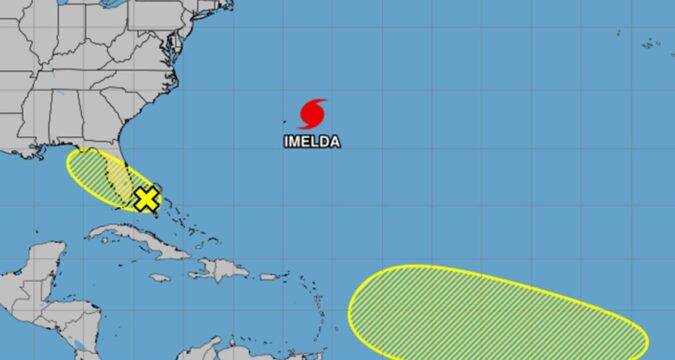
As of the NHC’s 2 a.m. tropical outlook, forecasters said a low-pressure area is set to form in the southwestern Atlantic waters between the northwestern Bahamas and South Florida’s east coast.
“Any additional development is expected to be slow to occur as the system moves northwestward across the Florida peninsula into the Gulf,” forecasters said.
The NHC gave it a 10% chance to develop in the next two to seven days.
The National Weather Service in Melbourne said the low could track across the state on Saturday.
“If this occurs, even a weak (non tropical) low would enhance low level convergence and heavy rain threat further across east Central Florida,” forecasters said. “If more heavy rain is anticipated this weekend, we may need a flood watch.”
The NHC also began tracking a tropical wave forecast to move off the coast of Africa by the weekend.
“Thereafter, this wave is forecast to interact with another disturbance in the eastern tropical Atlantic, and some slow
development of the combined feature is possible as the system moves westward to west-northwestward at 15 to 20 mph.” forecasters said.
The NHC gave it a 20% chance to develop in the next seven days.
If either were to develop, they would become the 10th tropical cyclone of the 2025 season, and could become Tropical Storm Jerry. After that, the next name on the list would be Karen.
Hurricane Imelda forecast path as of 5 a.m. Thursday, Oct. 2, 2025. (NHC)
As for the ninth named storm, Hurricane Imelda, which had strafed Bermuda as a Category 2 hurricane with 100 mph winds on Wednesday night, was quickly moving away from the island and expected to become extratropical in the Atlantic.
As of the NHC’s 5 a.m. advisory, Imelda had maximum sustained winds that had dropped to 85 mph, making it a Category 1 storm, located about 170 miles east-northeast of Bermuda headed east-northeast at 30 mph.
Hurricane-force winds extended out up to 45 miles and tropical-storm-force winds extended outward up to 255 miles from its center.
Bermuda was still getting high winds with the elevated station at the National Museum of Bermuda recently reporting sustained winds of 56 mph and a wind gust of 70 mph.
The hurricane warning that had been in place was reduced to a tropical storm warning.
“On the forecast track, the core of Imelda will move farther away from Bermuda during the next several hours,” forecasters said. “Imelda is expected to become an extratropical low later today, with gradual weakening forecast for the next several days.”
Our satellites have been closely watching the tropics this week. In this two-day time lapse imagery, @NOAA’s #GOESEast has been tracking the path and intensification of #Imelda and #Humberto. #GOES19 #TimelapseTuesday. Latest: https://t.co/ScLdyBac9D https://t.co/xNvF3NJTqW pic.twitter.com/yvHDSYpReR
— NOAA Satellites (@NOAASatellites) September 30, 2025
So far the 2025 season’s nine named cyclones have all grown to tropical-storm strength. Four became hurricanes, with all but Imelda having grown into major hurricanes.
The National Oceanic and Atmospheric Administration in early August updated its season forecast to call for 13-18 named storms, of which five to nine would grow into hurricanes. Two to five of those would develop into major hurricanes of Category 3 or higher.
The U.S. has had just one landfall so far this season when Tropical Storm Chantal moved ashore in July in South Carolina. It’s the first time in 10 years the U.S. has avoided a hurricane landfall by the end of September, according to AccuWeather, a private U.S. weather forecasting company.
“This hurricane season so far is quite unique, with several close calls for the United States,” said Alex DaSilva, AccuWeather’s lead hurricane expert.
He noted that Humberto pulled Imelda away from the U.S. East Coast in what’s known as the Fujiwhara Effect, a rare phenomenon in the Atlantic in which two storms are so close together that they start rotating counterclockwise around each other.
Humberto and Imelda were a mere 467 miles apart earlier this week, the closest distance recorded between two Atlantic hurricanes since 1853, according to Michael Lowry, a hurricane specialist and storm surge expert.
While the Atlantic hurricane season is winding down, DaSilva urged people to remain alert.
“We expect atmospheric conditions that could support tropical storms and hurricanes well into late October and November this year,” he said.
Hurricane season runs from June 1 to Nov. 30.
The Associated Press contributed to this report.

