Tropical Storm Melissa is forecast to grow into a major Category 4 hurricane as it threatens Jamaica and then Cuba, but its effects on Florida remain uncertain, according to the National Hurricane Center.
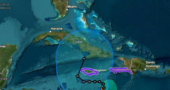
As of the NHC’s 5 a.m. advisory, Melissa had 45 mph sustained winds located about 165 miles south-southeast of Kingston, Jamaica and 275 miles southwest of Port au Prince, Haiti, but having nearly stalled forward movement.
“Melissa is nearly stationary, but a slow drift toward the northeast and north is expected later today and tonight. A westward drift is then forecast to begin on Saturday and continue through Monday,” said NHC Warning Coordination Meteorologist Robbie Berg. “On the forecast track, the center of Melissa is expected to move near or just south of Jamaica early next week.”
Tropical-storm-force winds extend out to 140 miles from its center.
A hurricane watch and tropical storm warning is in effect for Jamaica and southwestern Haiti.
“Gradual strengthening is forecast over the next day or so, followed by rapid intensification this weekend. Melissa is forecast to become a hurricane by Saturday and a major hurricane by Sunday,” Berg said.
Map: Will Hurricane Melissa hit Florida? Here are the latest tracking models
Hurricane conditions could begin across both Jamaica and Haiti on Saturday with tropical-storm conditions starting Friday.
The big threat could be excessive, life-threatening rainfall of 8-14 inches that could spread across both southern Dominican Republic and Haiti as well as eastern Jamaica through Sunday night.
“Additional heavy rainfall is likely beyond Sunday night; however, uncertainty in Melissa’s track and forward speed reduces confidence in exact totals,” Berg said. “Significant, life-threatening flash flooding and numerous landslides are expected in the southern Dominican Republic and eastern Jamaica, with catastrophic flash flooding and landslides anticipated in southern Haiti.”
Another 3-5 inches of rain are expected across the northern Dominican Republic, northern Haiti and western Jamaica through Sunday night with flooding impacts that could increase across western Jamaica next week.
“Strong westerly shear continues to affect Melissa, but there are some indications that the shear could gradually decrease over the next 24-36 hours,” Berg said. “At the same time, high ocean heat content values and stronger upper-level divergence should help to induce strengthening. There is fairly strong agreement among the
intensity models that a period of rapid intensification could begin in about 24 hours, and the NHC forecast shows Melissa becoming a hurricane in 36 hours.”
Tropical Storm Melissa Update – Thursday, October 23
NHC Director Dr. Michael Brennan provides an update on Tropical Storm Melissa and the risk of heavy rainfall and flooding across portions of Jamaica, Haiti, and the Dominican Republic. pic.twitter.com/HRafb2OUr7
— National Hurricane Center (@NHC_Atlantic) October 23, 2025
The long-term forecast has the storm growing into a major hurricane reaching Category 3 strength with 115 mph sustained winds and 140 mph gusts on Sunday while its path has it sliding from east to west just south of Jamaica.
It’s then forecast to grow into a strong Category 4 storm with 145 mph sustained winds and 175 gusts with a major shift to the north that would bring it toward Cuba by Wednesday.
Just where Melissa will be by mid-week and how intense has a great level of uncertainty, and relies on dominoes happening over the United States, according to the National Weather Service in Melbourne.
“While model consensus continues to keep Tropical Storm Melissa well to the south of Florida through the next five days, forecast confidence remains lower than normal due to uncertainty in the storm`s track, especially mid to late week,” forecasters said.
A surface low tracking across the Southeast will depart Monday or Tuesday and weak high pressure will build over the Gulf and Florida in its wake.
“Model consensus expects a mid-upper level trough stalling over eastern US ushering another front quickly through mid week, but models diverge how quick the following high pressure moves into the southeast, which combined with uncertainty in Melissa`s position, results in wide differences how tight the pressure gradient will be, its orientation, and moisture levels,” forecasters said.
Forecast computer tracks, known as “spaghetti models,” on Wednesday show Tropical Storm Melissa making a turn north in the southern Caribbean. But the models show low confidence in where and when that turn will happen. (tropicaltidbits.com)
Most long-term models have the storm tracking across Cuba and moving toward the Turks and Caicos or off to the northeast taking the threat away from Florida.
“While forecasts have been keeping Melissa clear of Florida, any storm in the Caribbean bears watching for the local area and residents and visitors should continue to monitor official National Hurricane Center updates,” forecasters said.
Melissa, which formed on Tuesday, became the 13th tropical cyclone of the season.
Four so far have grown into hurricanes, and three of those became major hurricanes. Only one, Tropical Storm Chantal, made a U.S. landfall this year.
Hurricane season runs from June 1-Nov. 30.

