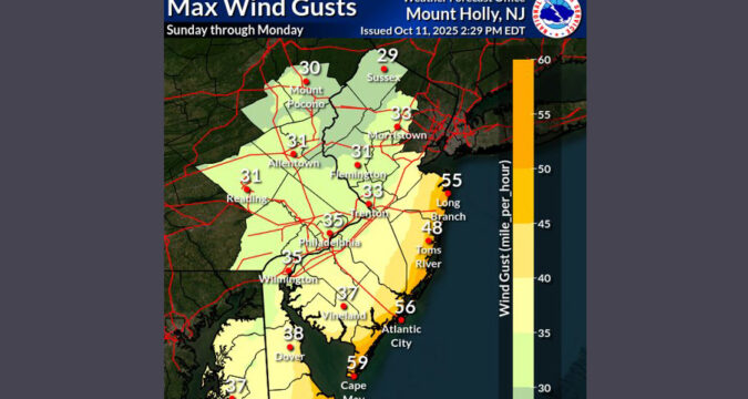
The Lehigh Valley could see wind gusts of more than 30 mph Sunday afternoon and evening as a nor’easter is set to bring significant flooding and damaging winds to coastal areas of New Jersey and Delaware.
Storm-force winds of 50 to 60 mph are expected along the coast, according to the latest National Weather Service forecast, which warns of potential power outages and downed trees.
A wind advisory for coastal areas lasts through Monday. Meanwhile, forecasted rainfall totals between now and Monday continue to drop, with 1 to 3 inches expected near the coast and lower totals inland.
Despite the reduced rainfall totals, damaging coastal flooding is the primary threat from the storm. Along the Delaware and New Jersey coasts, the weather service warns that “widespread roadway flooding, impassable roads, and inundation of structures are increasingly likely.” Very dangerous surf conditions are expected, as winds could whip waves up to 20 feet.
Rainfall totals continue to trend lower with 1-3 inches of rain near the coast and lower totals inland. Coastal areas could see a compounded impact with heavy rain on top of moderate to major tidal flooding during the high tide cycles. (4/4) pic.twitter.com/xTAk2xxQog
— NWS Mount Holly (@NWS_MountHolly) October 12, 2025
Back in the Lehigh Valley, rain from the storm is most likely Sunday night into Monday, with the weather service forecasting a 90% chance of precipitation. During the day Sunday, the chance of precipitation is 50%.
Rain from the storm should move out of the Lehigh Valley by Monday night. The extended forecast for the region shows that wind gusts could linger through Tuesday. The rest of the week is expected to be be clear, with highs in the 60s.
Here’s the extended National Weather Service forecast for the Lehigh Valley:
Sunday: A chance of rain. Cloudy, with a high near 64. Northeast wind around 15 mph, with gusts as high as 25 mph. Chance of precipitation is 50%. New precipitation amounts of less than a tenth of an inch possible.
Sunday night: Rain. Low around 53. Breezy, with a northeast wind around 20 mph, with gusts as high as 30 mph. Chance of precipitation is 90%. New precipitation amounts between a tenth and quarter of an inch possible.
Monday: Rain. High near 59. Breezy, with a northeast wind 15 to 20 mph. Chance of precipitation is 90%. New precipitation amounts between a tenth and quarter of an inch possible.
Monday Night: Rain likely, mainly before 7pm. Cloudy, with a low around 53. North wind around 10 mph. Chance of precipitation is 60%. New precipitation amounts of less than a tenth of an inch possible.
Tuesday: Partly sunny, with a high near 69. North wind around 10 mph, with gusts as high as 20 mph.
Tuesday Night: Partly cloudy, with a low around 50.
Wednesday: Mostly sunny, with a high near 64.
Wednesday Night: Mostly clear, with a low around 41.
Thursday: Sunny, with a high near 60.
Thursday Night: Clear, with a low around 38.
Friday: Sunny, with a high near 62.
Friday Night: Mostly clear, with a low around 40.
https://www.mcall.com/2025/10/12/allentown-weather-noreaster-sunday-updates/

