The Indiana Department of Environmental Management has published a new way for residents to keep track of restoration progress for one of Lake Michigan’s most polluted waterways.
On Monday, IDEM announced that it published an interactive map tracking updates on the restoration process for the Grand Calumet River area of concern, which is located in Northwest Indiana.
The map takes visitors through six stages, starting with general information and background about the area and ending with most recent updates on the process.
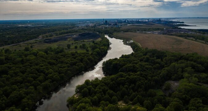
The Grand Calumet River area of concern spans from Gary, East Chicago and Hammond and Whiting, according to IDEM’s website, and it’s one of the 43 identified Great Lakes areas of concern, which focus on contaminated lakes, rivers and harbors. Of the 43 areas, 26 are located in the U.S., 12 in Canada and five span both countries.
Areas of concern have various impairments, including fish tumors or other deformities, added costs to agriculture or industry, and beach closure, according to IDEM’s map. Issues in the river can also lead to decreased wildlife populations or a loss of habitat.
The Grand Calumet River and Indiana Harbor Ship Canal — located in East Chicago — were polluted from more than a century of industrial and municipal wastewater discharges, and caused multiple grassroots organizations to advocate for cleanup measures along the river. The area was included as one with severe impairment of beneficial uses in 1981, according to IDEM.
The interactive map shares updates to the Grand Calumet River area of concern, saying that as of January 2025, more than four million cubic yards of contaminated sediment have been remediated and more than 1,000 acres of habitats have undergone systematic restoration.
More than $300 million has been invested in sediment remediation and $9 million was spent on habitat restoration. Two impairments were removed in 2011 and 2012, which were added costs to agriculture or industry and restrictions on drinking water consumption or taste and odor problems.
By 2030, IDEM hopes to have construction completed for sediment remediation in the Lake George Canal, Grand Calumet River Junction Reaches Project and portions of the river’s east branch.
The agency also expects that 1,000 acres of habitat will be completed this year, according to the interactive map.
IDEM and other agencies are also working on the Pine Station Ponds Project, which is in design and will support other restoration efforts by isolating contamination, creating submergent and emergent wetlands and controlling invasive species.
IDEM has worked with various agencies, including the U.S. Army Corps of Engineers and the U.S. Environmental Protection Agency to help with restoration efforts. Northwest Indiana organizations that have helped include the East Chicago Waterway Management District, Lake County Parks and Recreation Department, Hammond Port Authority, Shirley Heinze Land Trust and Save the Dunes Conservation Fund. The cities of East Chicago, Gary, Hammond and Whiting have also helped.
To view IDEM’s interactive map, visit the collection online.

