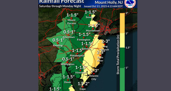
Rainfall totals for the Lehigh Valley and other inland areas are now trending downward as a nor’easter is set to cause flooding, beach erosion and high winds along coastal areas of New Jersey and Delaware, according to the latest National Weather Service forecast.
The rainfall forecast for Sunday and Monday across eastern Pennsylvania is now in the 0.5 to 1 inch range. On Friday, projected rainfall amounts were trending closer to 2 inches across this region.
Confidence continues to grow for significant impacts from major coastal flooding and substantial beach erosion with the coastal storm Sunday-Monday.
Attached is the latest information: https://t.co/JiD09ByGTv pic.twitter.com/n1ImfYewzP
— NWS Mount Holly (@NWS_MountHolly) October 11, 2025
Wind will be a factor, with gusts of up to 35 mph possible in the Lehigh Valley, according to the weather service.
Along the Jersey shore, it’s a much different story, as “widespread significant impacts” are “increasingly likely,” according to the weather service’s latest storm briefing issued Saturday morning.
Isolated flash floods are possible in the coastal areas of New Jersey and Delaware, but the bigger story will be moderate to major coastal flooding during high tides Sunday Monday. Most of the coast is under a coastal flood warning.
“Widespread roadway flooding, impassable roads, and inundation of structures are increasingly likely,” the weather service said, noting that evacuations are possible. “Coastal residents are urged to heed any warnings and follow guidance from local officials.”
The storm will lead to dangerous marine conditions, with beach erosion very likely. Dangerous seas of 15-20 feet are possible in the ocean, and extremely rough waters are expected within Delaware Bay, according to the weather service.
Wind gusts of 50-60 mph are possible Sunday and Monday along the coast, which could lead to significant tree damage and power outages.
Ahead of the storm, New Jersey issued a state of emergency starting Saturday night for all 21 counties.
Here’s a look at the extended forecast for the Lehigh Valley:
Saturday: A chance of showers, mainly after 1pm. Mostly cloudy, with a high near 68. East wind 5 to 10 mph. Chance of precipitation is 40%. New precipitation amounts of less than a tenth of an inch possible.
Saturday night: A chance of rain. Cloudy, with a low around 55. Northeast wind 10 to 15 mph. Chance of precipitation is 50%. New precipitation amounts between a tenth and quarter of an inch possible.
Sunday: Rain likely, mainly after 2pm. Cloudy, with a high near 65. Breezy, with a northeast wind 15 to 20 mph, with gusts as high as 35 mph. Chance of precipitation is 60%. New precipitation amounts between a tenth and quarter of an inch possible.
Sunday Night: Rain likely. Cloudy, with a low around 53. Breezy, with a northeast wind around 20 mph. Chance of precipitation is 70%. New precipitation amounts between a tenth and quarter of an inch possible.
Columbus Day: Rain likely. Cloudy, with a high near 61. Breezy, with a northeast wind around 20 mph, with gusts as high as 30 mph. Chance of precipitation is 70%. New precipitation amounts between a quarter and half of an inch possible.
Monday Night: A chance of rain. Mostly cloudy, with a low around 52. Chance of precipitation is 50%. New precipitation amounts of less than a tenth of an inch possible.
Tuesday: Partly sunny, with a high near 68.
Tuesday Night: Partly cloudy, with a low around 49.
Wednesday: Sunny, with a high near 67.
Wednesday Night: Mostly clear, with a low around 43.

