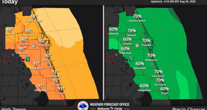
Central Florida has a high chance for rain Saturday, especially along the eastern counties, according to the National Weather Service.
The NWS in Melbourne gave the the region a 55% to 70% chance for precipitation that increases in the afternoons and evenings.
“Florida remains within the base of a sprawling and anomalous trough centered across the eastern half of the continental United States,” forecasters said. “At the surface, a relatively weak pressure gradient exists, though a stationary front sits just to our north.”
That means deep moisture pooling near the boundary that will combine with a westerly steering flow that ups the chances for storms especially along the eastern half of Florida’s peninsula.
“Typical convective hazards for late August remain in play – including the potential for brief weak rotation and funnel clouds where stronger boundary collisions and interactions take place,” forecasters said. “A low risk for excessive rain persists given the enhancement to the summertime pattern – we`ll pay special attention to convection that develops over areas that have seen higher rainfall totals over the past 48-72 hours.”
Beachgoers are warned to watch the western sky in the afternoon.
Temperatures are normal for this time of year expected to hit the upper 80s and lower 90s in the interior, with heat indices ranging the feels-like temperatures from 96-103.
https://www.orlandosentinel.com/2025/08/30/storm-chances-higher-saturday-for-central-florida/

